The Tobucksy County Newsletter is our official Society publication, bringing you regular updates on Society activities, events, and research alongside in-depth articles from Society members and guest writers. The Newsletter is a quarterly, digital publication, with print copies available upon request!
Vol. 37, No. 2 (Digital 2.2): April-June, 2026
Welcome back to the Tobucksy County Newsletter! This edition includes a review of recent Society events/programming, along with a an article researched by Society Vice President Adeline Whisenhunt.
Current PCGHS Board
- President – David Beall
- Vice President – Adeline Whisenhunt
- Secretary – Julie Wolf
- Treasurer – Jim Young
- Members At-Large: Melinda Dobson, Paige McClain, Christina Thurber
Society Highlights March-June 2026
- Monday, March 30– David Beall presents “Discover Your Roots: Exploring the Dawes Roll” at the McAlester Public Library.
- April – Special edition of Southeast Oklahoma Library System’s Beyond Words magazine publishes “Oklahoma’s OG Highway: Meet the Mother Road’s Older Sister,” by Lacey Sudderth, featuring an interview with Adeline Whisenhunt on the history of the Jefferson Highway.
- Tuesday, April 7 – PCGHS monthly meeting, featuring “Let’s Talk About Genealogy,” presented by David Beall.
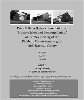
- Tuesday, May 5 – PCGHS monthly meeting, featuring “Historic Schools of Pittsburg County,” presented by Patsy Miller.
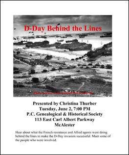
- Tuesday, June 2 – PCGHS monthly meeting, featuring “D-Day Behind the Lines,” presented by Christina Thurber.
- Saturday, June 13 – Julie Wolf presents “The History of McAlester Regional Airport” as part of the Airport’s Community Open House and Fly-In.
- Friday, June 19 – PCGHS presents “The Origins of Juneteenth” informational display as part of McAlester Juneteenth celebrations.
- Monday, June 29 – Christina Thurber presents “D-Day Behind the Lines” at McAlester Public Library.
Featured Article: The Jefferson Highway in Downtown McAlester
Research by Adeline Whisenhunt
In 2023, the Society was approached by a local realtor looking to donate a suitcase left behind by previous tenants in a for-sale home. Within the suitcase were a number of personal photos, including examples of early photography methods such as tintypes. Most exciting, however, was the photograph included below:
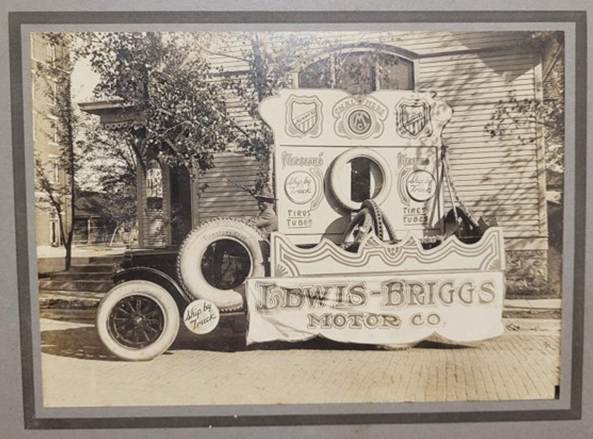
The photograph depicts a parade car decorated with signage for the Lewis-Briggs Motor Company. Later research revealed this to be a McAlester-based company which operated from 1916 to 1920. The parade vehicle was determined to be a 1918 Maxwell Flatbed Truck, and while the driver appears to be dressed in a WWI “doughboy” uniform, the absence of patriotic decorations elsewhere on the vehicle suggests the parade was not connected with a patriotic or military event. Instead, it was determined that the parade was for the Spring Festival and Regional Automotive Show in McAlester on May 22, 1919.
The late Tom Crowl assisted with research by confirming the background buildings to be Diamond Hardware Store (the multi-story brick building to the left) and the First Presbyterian Church (the white building directly behind the car). Reference to the 1927 Sanborn Fire Insurance Map in the Society library clarified the location of the photograph to be the corner of S 2nd and E Cherokee, the cross-street of the JD Jones building (later the Million Ford building, now Compassion 365).
All this triangulation may seem unnecessary, if not for an important detail from the photo:
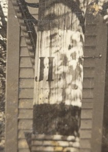
The telephone pole in the background features a marker consisting of horizontal bands with a “JH” symbol. This marker designated the street as part of the Jefferson Highway route in McAlester.
The Jefferson Highway is a historic highway running from Winnipeg, Canada to New Orleans, Louisiana. Established in 1915 as a tourism route, the highway roughly follows the western edge of the Louisiana Purchase, leading it to be named after President Thomas Jefferson. Prompted by the success of the Lincoln Highway (which runs from California to New York), the creation of the Jefferson Highway saw multiple cities, and even whole states, along the proposed route competing to be an official Jefferson Highway destination. As Oklahoma’s route was being defined, McAlester’s Ford Dealership Owner – J. D. Jones, was the President of the Jefferson Highway Association of Pittsburg County by 1919.
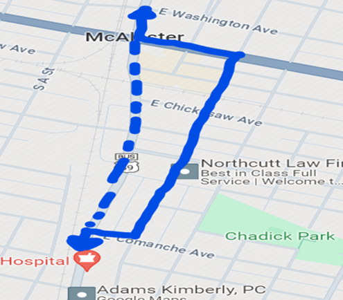
News articles from that same year discuss the route being marked through McAlester, including a turn along Comanche Street from Main to S 2nd and references to the highway’s run along S 2nd being designed to show tourists “the larger buildings and better resident section,” along with the burgeoning automotive district. In short, the route followed Main Street/Business 69 through most of McAlester, with this short detour along Comanche to 2nd, then 2nd to Grand (now Carl Albert), before returning to Main and continuing north of town.
Not only did the telephone pole help to rediscover this route, but it also provided photographic evidence of the route, which has since spurred McAlester to incorporate information on the Jefferson Highway into city tourism marketing, along with inspiring multiple members of the McAlester community to participate in the International Jefferson Highway Association’s efforts to start a state-specific chapter. The city even hosted the 2025 International Jefferson Highway Conference, showing that just like in the early days of the highway, McAlester remains an important part of highway efforts.
References:
“Local Items in Brief.” McAlester News-Capital. April 17, 1919.
“First and Last.” McAlester News-Capital, September 9, 1919.